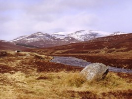
Currently browsing category

Day Meets

21st April 2019 – Ben Lawers

Grid Ref 594416, Map No. 51 Ben Lawers is the 10th highest mountain in the UK and the highest in the Southern Highlands. The mountain is at the centre of a chain of 7 Munros which fit people can walk in one day. The NTS have installed a large car-park and …

17th February 2019 – Lochnagar & Station Hotel

Map 44, Grid Ref 310851 “England! thy beauties are tame and domestic, to one who has roved o’er the mountains afar. Oh, for the crags that is wild and majestic! The steep frowning glories of dark Lochnagar!” So wrote Lord Byron who climbed Lochnagar from Invercauld by the Garbh Allt, …

2018/2019 Indoor Meets : Program Of Events

Venue: Station Hotel Function Room Stonehaven at 8pm New Cost £2 and New Time 8pm 30th October 2018 Aberdeen Mountain Rescue Team: (Don’t Go Home by Accident!) Kenny Webster 27th November 2018 : SMHC – the Last 40 Years Jack Mitchell 29th January 2019 : Trekking to Everest Base Camp and Gokyo Lakes, …

18th August 2019 – Drumochter Hills

Map 42, Grid Ref 628793 Enough Munros to keep anyone going in a day on either side of the pass with a good high start and a couple or three Corbetts for those heading down that route. Either a bike to return to the start along the Sustrans route through …

21st July 2019 – Ben Wyvis

Map 20 – Grid Ref 463684 Ben Wyvis is a very prominent hill to the north of Inverness. It boasts a main Munro summit Glas Leathad Mor (1046m), 3 subsidiary tops and a top demoted from the original Munro list. The stalking season will be in force and the estates prefers ascent …

15th April 2018 – Glen Callater

Map 43, Grid Ref 156883 Starting from the car park at Auchallater, there are several options for today’s walk. The Corbett Creag nan Ghabar is a fine viewpoint and would be good choice for those amongst us who are,feeling less energetic. The Munro, Carn an Tuirc may be climbed via …

15th July 2018 – The Northern Corries

Map 36, Grid Ref 990040 The Northern Corries sitting on the edge of the 1245m. Cairngorm plateau overlooking Strathspey. Coire Cas, Coire an t Sneachda 1176m. And Coire Lochain 1215m. being the highest point of the coire headwall. They offer a huge amount of climbing with excellent routes at all …

19th August 2018 – The Lomond Hills

Map xx, Grid Ref 704740 ?? The Lomond Hills have a rich and varied history. From the Iron Age are the remains of several hill forts, which can be found around the summits of both East and West Lomond as well as at Maiden Castle, a grassy knoll that lies …

21st October 2018 – Linn O’ Dee

Linn o Dee (Map 43, Grid Ref 063897) This is the gateway to the high mountains of the southern Cairngorms and a great access point into Glen Derry and Luibeg via Derry Lodge, and through the superb expanding Caledonian pinewoods in these two scenic mountain passes, or via the Chest …

16th September 2018 – Invercauld

Distance: 16 miles/26km Ascent: 3215ft/980m Time: 6-7 hours Start/finish: Large layby on A93 at Inver, opposite red telephone box (GR: NO 234938) Maps: Ordnance Survey 1:50,000 Landranger sheets 43 (Braemar & Blair Atholl) and 44 (Ballater)Route: Follow minor road, then track to Ballachlaggan. Turn R on grassy path, climb past …

16th December 2018 – Glen Tanar

Map 44, Grid Ref 480965 Pay for car parking so remember some change. There is a visitor centre & toilets near the car park. Many route options for the shorter winter days. There are plenty of well marked paths in Glen Tanar, on either side of the Water of Tanar. …

19th February 2017 – Lochnagar

Map 44, Grid Ref 310851 “England! thy beauties are tame and domestic, to one who has roved o’er the mountains afar. Oh, for the crags that is wild and majestic! The steep frowning glories of dark Lochnagar!” So wrote Lord Byron who climbed Lochnagar from Invercauld by the Garbh Allt, …

16th April 2017 – Glen Glova

Map 44, Grid Ref 283761 Glen Doll lies within the Cairngorm National Park at the top of Glen Clova, in an area of steep hills, Corries and Munros. It includes Corrie Fee Nature Reserve which has many endangered plants. The ancient track Jocks Road starts in the glen and ending …

16th July 2017 – Invercauld – Culardoch & Carn Liath

Map 43/36??, Grid Ref 187914 Vast kilometres of tracks for cycling and walking some of the higher tops, travelling via old rights of way, passing several crofts, the area has a rich history. With good access to Ben Avon, Ben a Bhuird, Cullardoch, Carn Liath and Loch Builg. Great views …

20th August 2017 – Glen Muick

Map 44, Grid Ref 274818 Corrie Chash and Broad Cairn (6180m) – Cairn Bannoch (1012m) Loch Muick occupies a dark, steep sided glen on the Royal family’s Balmoral Estate. It offers numerous levels of walking for all, including families. The Glas- Alt- Shiel Queen Victoria’s holiday home she built for …

15th October 2017 – Hills of Cromdale

Map xx, Grid Ref 075286 Often known as the Haughs o Cromdale, a long arc above the old settlement of Cromdale. These hills held many illicit stills for whisky and is home to one of the oldest distilleries left. The summit to Clash nam Piobair or best known as the …